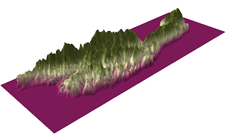
I chose to do my DEM of California's largest island: Santa Cruz Island, one of the Channel Islands off the coast of Southern California. The reason that I chose an island is that I thought that perhaps its DEM would look particularly interesting, and I think that it does. For example, for the most part, the ocean surrounding the island is completely pink, which according to the legend, means it has a value of roughly -3.75 meters. The boundary of the island is, therefore, very clearly marked, and we see that the ocean here is below the average sea level. Also, we can see that the inner most parts of the island have the highest elevations. According to the Channel Islands National Park website, Santa Cruz island contains two mountain ranges, the highest peaks on the islands (rising above 2,000 feet), a large central valley/fault system, and deep canyons. These features are quite clear when looking at my shaded relief model.
Extent Information:
Top 34.0949999991
Left -119.940555555
Right -119.503055555
Bottom 33.9383333324
Spatial Reference:
GCS North American 1983 |
| 3D Image |


No comments:
Post a Comment